 |
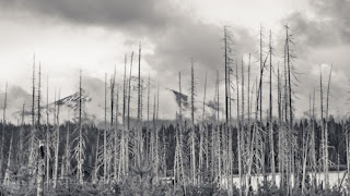
| Odell Butte and Diamond Peak at Crescent Lake |
 |
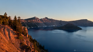
| The Sun breaching the crater rim |
How does one drive seventy miles to catch Crater Lake at sunrise on the longest day of the year? You have to get up at 3:00 AM and hit the road at 3:30 AM and arrive by 5:00 AM. Is this painfully early? Yes it is.
Is it totally worth it? Yes it is.
As early as it was, Crater Lake proved to simply stunning. I have lived in Oregon most of my life, save four years I was in the military. I was born here, grew up here and returned here after I left the military. Yet given my growing number of years in Oregon, exceeding four decades, I have seen very little of Oregon. In the last decade I have created a bucket list of sorts. My bucket list includes seeing sites in my own home state that I have not seen yet. Crater Lake was at the top of that list. Well now I get to scratch that off my list.
I was awe struck by the shear size of the caldera, at over 5 miles wide. Photographs absolutely no justice to the shear size of the crater. It is estimated that Mt. Mazama, now Crater Lake, was at a height of 11,000 to over 14,000 feet (larger than Mt. Shasta). If you add in the fact that Crater Lake, the deepest lake in North America and the 9th deepest in the world, is 1949 feet deep, nearly one vertical mile of mountain collapsed into the caldera, ejecting up to 14 cubic miles of magma into the air in the most violent eruption ever in the Cascade Mountains.
 |
| Add caption |
14 cubic miles may initially sound mild, but think of it like this, 14 miles high by 14 miles wide by 14 miles deep. In comparison to the 1980 eruption of Mount Saint Helens; Saint Helens' eruption had a Volcanic Explosive Index (VEI), which is used to measure the explosive power of a volcano, of 5, but just barely and had very little magma ejection. Krakatoa in 1883, one of the most powerful explosions in modern recorded history measured a 6 on the VEI scale. Mazama's collapse and subsequent magma eruption measured a 7 on the VEI scale. The only larger would be Yellow Stone, 640,000 years B.C. The source of this information can be found at:
http://en.wikipedia.org/wiki/Volcanic_Explosivity_Index
Ash from the eruption, known as Mazama ash for its unique silica composition, covered nearly all of Oregon and reached as far as Washington, northern California, Idaho, western Montana, and parts of Utah, Nevada, Wyoming, Alberta, British Columbia, and Saskatchewan.
After the trip to Crater Lake was complete we came home, took naps, had lunch and proceeded to photograph around the lake again, well into the night. If you haven't made it to Crater Lake, do yourself a favor and get there soon. It is stunning, beautiful and well worth the trip. Come back tomorrow for a free wallpaper you can download and enjoy on your computer. Until then, enjoy a couple more of the photos I took from the day below. I took many more photos of Crater Lake, but those will be in future blog posts.
 |
| Diamond Peak |
 |
| Odell Butte at night |


